Freestone · Limestone · Masham / Lower Wensleydale, GB-ENG

River Burn

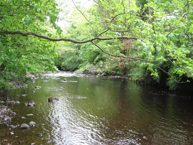
The River Burn flowing near Masham in North Yorkshire

Small intimate river near Masham with the private, wild feel that makes Yorkshire fishing special.

Prime · Grayling
Sawyer Pheasant Tail Nymph · 14–18
Primelive now
About as good as it gets
Low and clear — careful approach country. Take your time — read the water before you cast.
90% confidence
What moved it
  • LevelProxyvia River Ure
  • Water temp8.3°C
  • ClarityClear
Today's fly
Sawyer Pheasant Tail Nymph
Sawyer Pheasant Tail Nymph14–18
in season · all-rounder · regional default
Conditions on the water
Proxy gauge
Level
Steady
Proxy
via River Ure
Water temp8.3°C
ClarityClear
Weather4°C
WindSW 14 km/h
Pressure1014 hPa
Rain · recent0.0 mm
Rain · ahead0.7 mm

No gauge on this water — conditions are inferred from River Ure. The trend transfers, the absolute level does not.

Water temperature for Grayling
Ideal
8°C est.ideal 4–14°C
0°14°28°
How to fish it · for Grayling
When
Midday window — grayling feed best from late morning into early afternoon.
Where
Work runs and glides — grayling shoal in the bottom third of the water column.
Method
Tight-line nymph the bottom third with weighted patterns.
Kit
10 ft #3 rod, floating line, long leader to 4 lb fluoro for nymphs.
Why this works
Excellent — water temperature is right today, though insect activity could be better. Grayling feeds actively in cold water — peak winter sport.
Likely species
Hatch timeline · todayQuiet day

Hatch predictions

Today's headline hatch shown — see all 7 active hatches hour by hour as a supporter.

Start free trial

14-day free trial. Cancel anytime.

Sub-surface · on the nymphunder the surface

Hatch predictions

Top nymph shown — see all 3 guilds as a supporter.

Start free trial

14-day free trial. Cancel anytime.

Beyond the hatch · worth watchingambient prey(1)

Hatch predictions

Supporters see what else is on the menu.

Start free trial

14-day free trial. Cancel anytime.

Evidence
Survey-backed · regionalHigh confidence

Backed by regional invertebrate surveys; no sampling on this exact reach yet.

Through the year
0–3 scale · November highlighted
J
F
M
A
M
J
J
A
S
O
N
D
Trout seasonSeason
1
2
2
2
2
2
1
Daddy Long LegsHatch
2
3
3
2
CapererHatch
2
3
3
2
Hawthorn FlyHatch
2
2
GrannomHatch
2
2

Numbers are intensity 0 (none) to 3 (peak) — a guide, not a guarantee.

Ranked for today
Grayling fly box
North Country spider water

A small, secret sort of river — runs, holes, and overhanging cover where every cast has to count. Dry fly and spider are equally at home, and the Hare's Lug soft hackle is a local article of faith.

Local classics: Snipe & Purple·Waterhen Bloa·Hare's Lug
What's coming
Plan ahead
5-day outlook
Other water nearby · 5
Gallery · 2
  1. The River Burn flowing near Masham in North Yorkshire
    River Burn near Masham, North Yorkshire
  2. Terrain map of the venue
    Terrain map
About this water

Runs, holes, and pools with overhanging cover where stealth is paramount. Dry fly and spiders are equally at home; the Burn's scale suits both. The Hare's Lug (hare's ear soft hackle) tradition is strong here — a distinctively Yorkshire pattern that blurs spider and nymph. The Burn joins the Ure just south of Masham. Overhanging trees demand accurate short casts and roll-casting. Syndicate and estate-managed access (Fly Fishing Yorkshire syndicate, Swinton Estate). A river for anglers who value intimacy over size.

  • Limestone
Water quality (WFD)
  • Ecology: Moderate
  • Chemical: Fail
What this classification means

Classification for the fished main stem of the River Burn at Masham / Swinton — EA waterbody 'Burn from Leighton Beck to River Ure' (GB104027069310), Ure Middle and Lower operational catchment, Swale Ure Nidd and Ouse Upper management catchment, Humber river basin district. Latest EA data (updated 17 March 2025), Cycle 3 2022: Moderate ecological status, held at Moderate since 2019. Heavily modified water body sitting within the North Pennine Moors SAC/SPA. The step down from earlier Good classifications is driven by the fish element (RNAG: surface-water abstraction affecting flow) plus a phosphate 'suspect data' reason-for-deterioration; invertebrates, macrophytes and the other physico-chemical elements are High/Good. Chemical 'Fail' reflects the England-wide ubiquitous-substance failure (mercury and PBDE in biota — measures delivered, awaiting recovery), not a Burn-specific pollution event; the 2022 cycle itself records chemical as 'does not require assessment'. Classifying monitoring sites include Burn at Masham (Badger Lane Bridge) and Burn at Swinton Saw Mill Race. Note: the prior entry pointed at GB104027068800 (Ings Goit from Source to Burneston Beck), a separate small waterbody in the Swale catchment, not the Burn — corrected 2026-06-18.

EA (England) · GB104027069310

The full read · show the working · for Grayling · confidence 90%
How the 85 is built — score × weight = contribution
Temperature100 × 28%28.0
Flow80 × 22%17.6
Clarity85 × 18%15.3
Feeding Time90 × 13%11.7
Pressure80 × 7%5.6
Insect activity54 × 12%6.5
Conditions total= 85
Can you trust it?
Water temperatureair-to-water estimateestimated
Level / flowproxy via River Ureproxy
Prey activitysurvey-backed invertebrate datasurvey
Directions
Seasons & zones
  • Trout 22 March → 30 September
Related guides
Casting instructors near here
Booking & contacts
At a glance

River Burn is a freestone river in Masham / Lower Wensleydale, England. The catchment geology is recorded as limestone, and the water sits at about 90 m above sea level. The river is described as roughly 18 km long. Species listed for this water: brown trout and grayling. The trout season is recorded as running from 22 March to 30 September. Best window recorded for anglers: May to September (trout), October to December (grayling). Core methods listed: upstream nymph; dry fly; small streamer. Its Water Framework Directive ecological status is recorded as moderate. Nearby waters in our listings include Tanfield Lodge Lake at 5.0 km, Bellflask Fishery at 6.0 km and Leighton Reservoir at 7.0 km.